It’s about time that I let you in on a little secret called the Arran Coastal Way. When I walked the Ayrshire Coastal Path, I was rewarded with many beautiful views of the Isle of Arran. Even from miles away, I could tell that there are some lovely paths to be walked on the island. My mind was made up,’ That’s going to be my next walking holiday in Scotland.’
And it was everything I thought it would be. There’s a good reason why Arran is said to be ‘Scotland in miniature.’ If you are thinking of doing the ACW as well, allow me to share a few words about the walk. Hopefully, you will find my thoughts and tips useful when planning your itinerary.
Overview of the Arran Coastal Way
- Length: 64 miles
- Region: Isle of Arran
- Start and finish: Brodick (circular)
- Time required: 5 to 8 days
- When to walk: April to October
- Difficulty: Moderate to difficult
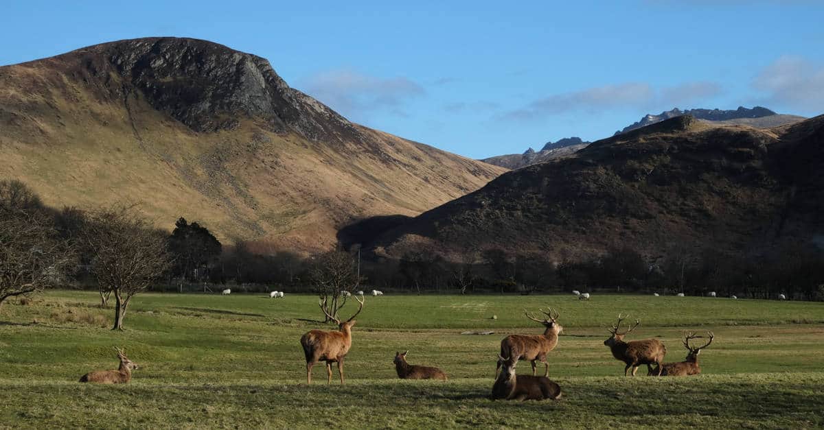
Providing walkers with an opportunity to experience the abundant history, scenery, wildlife, and archaeology of this fascinating island, the Arran Coastal Way is truly a magnificent walk. The Way combines rolling hills, forest trails, and many varied habitats as well as tidal beaches and seaside paths.
The trail starts with a somewhat challenging walk around the coastal fringe of the mountainous part of the island but ends with much gentler landscapes. On top of the incredible range of landscapes, the Arran Coastal Way journeys through twelve lovely coastal villages. The settlements of Arran are well known for wonderful local produce, cheese, and whiskey. This is undoubtedly one of the best alternatives to the West Highland Way.
History of the Route
The idea of the Arran Coastal Way began back in the ‘90s. Two local enthusiasts, Dick Slim and Hugh McKerrell had envisioned a circular trail around the Isle of Arran, gathered an army of volunteers and a group of eager supporters, and established the ACW by 2003.
Scottish Natural Heritage, today known as NatureScot, recognised their great work and designated the Arran Coastal Way as one of Scotland’s Great Trails in 2017.
I always like to talk about Scotland’s Great Trails, but I don’t do it solely out of patriotic reasons. For a walk to become one of Scotland’s Great Trails, it must fulfil very strict criteria.
Each of these trails is largely off-road, but has a clearly defined path, has an official online presence, and offers a range of support services (although this varies greatly from trail to trail).
The Way has been a favourite for avid hikers and hillwalkers for quite some time. But it became really popular after the Arran Access Trust upgraded and way-marked the route.
Getting There
Glasgow is the closest major transport hub to Arran. If you are flying in, Glasgow Prestwick is the most convenient airport for Arran.
It takes just 20 minutes to get from Preswick to the Ardrossan ferry terminal by taxi. The price of the ferry journey between Ardrossan and Brodick is about £5.
I took the X36 bus from Glasgow to Ardrossan. However, there is a railway line from Glasgow Central to Ardrossan. It runs regularly and lines up with the ferry times in Brodick.
You can get an all in one train-ferry ticket. The option I chose was cheaper, but I had to wait about an hour for the next ferry.
The easiest way to plan your journey is to use the Traveline website.
If you are thinking of driving there, it can also be a convenient option. It takes about an hour to get from Glasgow to Ardrossan. You can leave your car in Ardrossan, there’s a large secure car park in the town, and then take the ferry.
You’ll need to book the ferry in advance if you want to bring your car to Arran. The ferry crossing takes one hour. It’s operated by CalMac.
Another option is to take Claonaig on the Kintyre peninsula to Lochranza. This is a circular trail, after all, so you can begin your walk pretty much anywhere you want.
If you want to use Glasgow as a base for other adventures, check out these 15 day trips from Glasgow.
Getting Around the Isle of Arran
The public transport links along the route are excellent. This allows you to easily skip a few sections of the trail or make detours. You can check the bus timetables on SPT’s website.
Moreover, it may not always be possible to find accommodation along the route. So, this is useful information in case you need to spend the night in one of the neighbouring towns or villages.
There are a few independent taxi drivers on the island as well. But, if you want to hire a taxi, you should book your ride in advance.
How Difficult Is the Arran Coastal Way?
The Arran Coastal Way is not a particularly long route, but it has a few challenging sections. There is some very rugged terrain along the coast. You will walk across boggy or pathless sections that are tiring and slow.
But, if you are not up for a tough walk, there are easier, lower-level or inland alternatives to some sections of the trail. Of course, you can also opt for an itinerary with shorter days. You can split up the sections however you want, especially if you plan on camping in the wild on Arran.
Nevertheless, you will undoubtedly enjoy the trail much more if you already have a reasonable level of fitness and some walking experience. To prepare for the range of walking you will face on the Arran Coastal Way, I recommend spending time on varying terrain.
Goat Fell
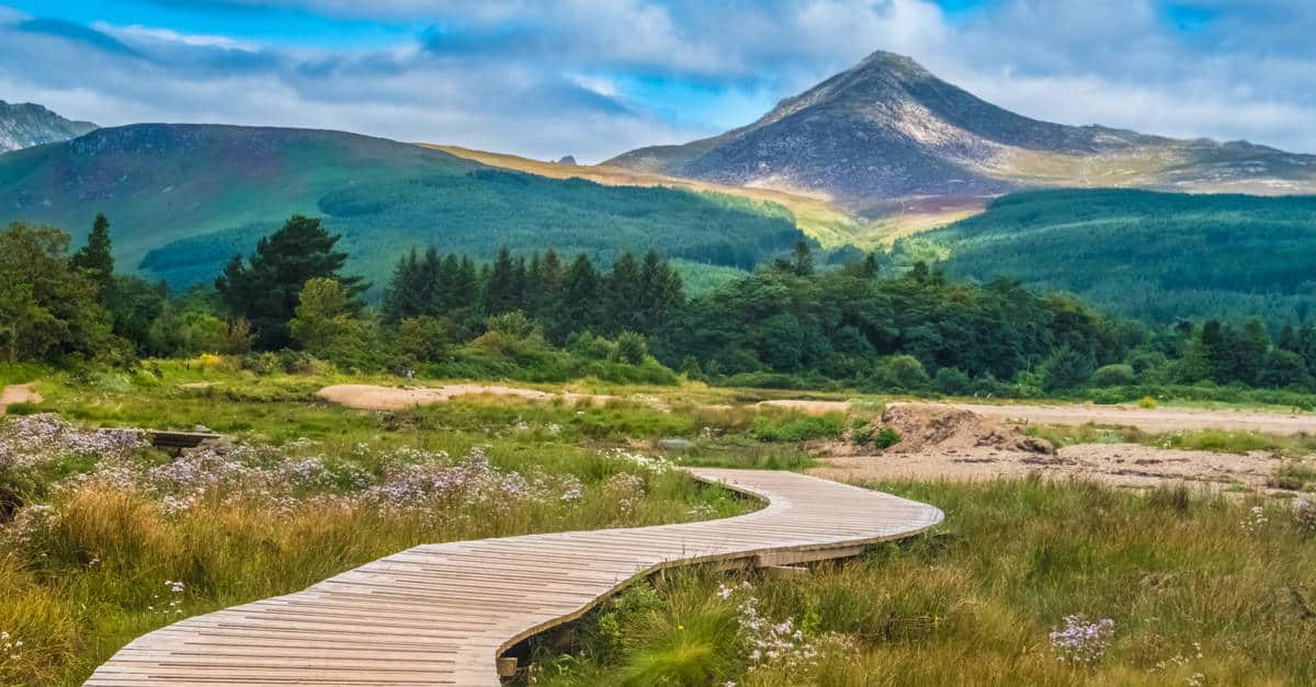
The first stretch is the most difficult part of the route. But if you are feeling adventurous, you can ascend Goat Fell, the highest mountain on Arran, at the beginning of your walk. This route involves a climb of 2860 feet. For those with ample experience and fitness, it should be a straightforward hillwalk.
I didn’t arrive in Brodick as early as I planned to, so I didn’t have the time to climb Goat Fell on my first day. However, I stayed in town for a couple of nights after completing my walk, so I climbed Goat Fell then.
I’d say that saving it for the end was even better. Looking down on Arran after you’ve completed the Way is pretty satisfying.
You can walk the ACW in either direction. I wanted to get the toughest sections out of the way early so I started the walk from Brodick to Lochranza.
Tide Times
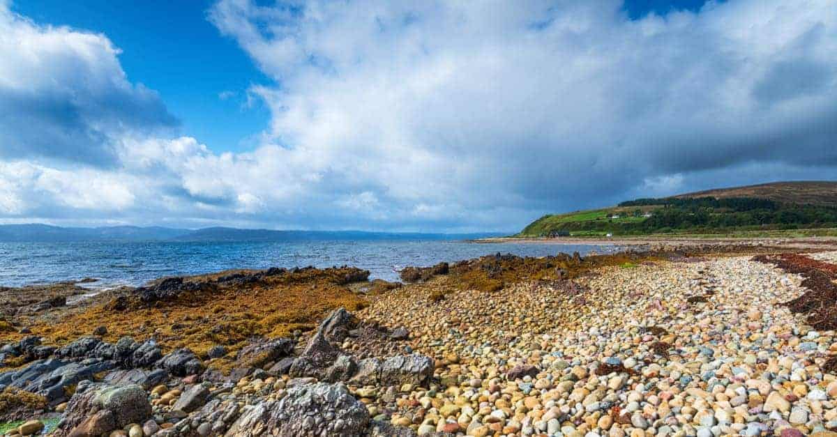
Steep climbs are not the only factor that can make your walk challenging. It’s also important to check the tides before setting out because some sections are impassable at high tide. The route pass almost all the best beaches on Arran.
Generally, you can avoid tidal difficulties by taking to the road. However, this isn’t always convenient.
The section between Bennan Head and Dippen Head can be a bit tough. The angular boulder fields below Dippen Head are especially rough, whereas the stretch along Bennan Head is impassable at high tide.
Dippen head is a tough but scenic scramble, so I recommend you wear good hiking shoes.
Some parts around Cordon and Ardlui are also impassable at high tide. Just for an hour, though.
A few sections of the trail around Clauchlands Point are underwater during high tide. The terrain higher up the beach is still passable, even though it is wet.
You can find the tide table for Isle of Arran on this website.
Waymarking and Navigation
The Arran Coastal Way is well marked and easy to follow for the most part. However, the waymarks are only at turns and junctions. These turn-offs can be miles apart along some longer sections of the trail.
So, looking for waymarks can be a waste of time and energy if you don’t know when to expect the next turn off.
Even though the route follows the coastline, the paths along the shore aren’t always clear. I don’t think that you will get lost, but it’s a good idea to bring a map. I found the Harvey Superwalker Map to be very useful. Ordnance Survey Maps are also a good choice.
If you plan to climb Goat Fell, you will need a compass. I didn’t buy a guidebook for this walk; I found all the information I needed on the internet and printed it out. But I had a chance to flick through the Rucksack Readers Guide and would say that it’s pretty useful and has some very handy maps. They update it every couple of years.
Best Time to Walk the Arran Coastal Way
You can walk the Arran Coastal Way all year round, at least in theory. Even in winter, you are unlikely to encounter ice and snow (except on the high ground). But most walkers choose to do the Arran Coastal Way between April and October.
In winter, the accommodation is limited, days are shorter, and the weather is poor. There’s always the chance of strong winds on Arrand, but particularly during winter.
Even if you don’t mind the wind it can disrupt your plans. Strong winds lead to ferry cancellations. You could easily get stuck on the island.
If you want sunshine, it’s best to do the walk in July or August. These are also the busiest months on the trail, but there are enough wide, open spaces for all walkers to enjoy.
May is a good month as well. The midges are not causing too much trouble and the weather is okay.
I did the walk in September. Even though the skies were grey almost every day, the daylight hours were long enough, wildlife was everywhere, and the landscapes still looked fantastic.
October can be a bit chilly and windy, but the Arran Coastal Way is still doable this time of year. Moreover, accommodation is cheaper.
All of this said, let’s not forget that Arran is Scotland in miniature. You can see four seasons in one day in Arran, just like you can in the rest of the country. Moreover, you will cross some boggier sections as well as a few rivers and burns.
You will need a good pair of waterproof hiking shoes, a few pairs of hiking socks, and weatherproof layers.
Check out our post on the best time of year to visit Scotland as well.
Accommodation on the Arran Coastal Way
Even though some hotels and B&Bs may be fully booked during the summer tourist season, finding accommodation shouldn’t be a problem.
Arran is pretty small and the public transport on the island is pretty good. This makes Arran Coastal Way one of the few long-distance routes that allow you to sleep in the same place for the entirety of your walk.
When you are done walking for the day, you can simply hop on the bus or call a taxi and get back to your accommodation.
There are plenty of B&Bs and hotels in Brodrick, the bustling Capital of Arran. I stopped at a great co-op supermarket as soon as I arrived at Brodrick to stock up for my walk. I recommend you do the same as some villages along the route have limited food shopping.
If you’d rather not stay in one hotel or B&Bs, there are accommodation options along almost every section of the trail. In some cases, you might need to make a short detour.
There are a few hostels and hotels available in Sanno and Corrie. However, you won’t come across any facilities between Sannox and Lochranza. You will find an SYHA hostel, B&B, and hotel in Lochranza.
At Catacol, you can stay at the inn/hotel. Further down the route, in Pirnmill, you will find a shop, a cafe, and B&B. There are no facilities between Pirnmill and Imachar.
On your way to Blackwaterfoot, you will pass next to the Machrie Bay Golf Course and Tearoom. In Blackwaterfoot, you will find a B&B, hotel, and a shop.
There are no facilities between Blackwaterfoot and Lagg. You will find a bunkhouse and an inn in Lag.
There is a hotel in Kildonan, and you will find a shop, B&Bs, hotels, and cafes in Whiting Bag.
In Lamplash, you will find one shop, cafes, B&Bs, and hotels.
You can search for accommodation (as well as designated campsites) on the Visit Arran website.
Baggage Transfer and Walking Holidays
There a few companies that offer both baggage handling and organise self-guided walking holidays on Arran Coastal Way. Celtic Trails Walking Holidays and Great British Walks Limited are some of them.
If you are looking for a company that only offers baggage transfer service, the Arran Coastal Way Baggage Co is the only one I can think of. However, they only offer this service to customers who are walking the ACW in an anti-clockwise direction.
The average price of a self-guided tour with baggage transfer is £55 per night per person.
Camping on the Arran Coastal Way
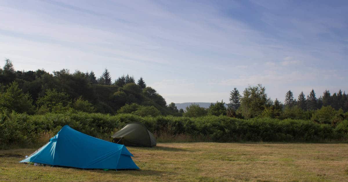
There are a handful of designated campsites on the ACW. However, wild camping is permitted in Scotland. When wild camping in Scotland, it’s important to adhere to the Scottish Outdoor Access Code and its guidelines.
It’s best to keep away from historic structures, roads, buildings, and enclosed fields of crops and farm animals.
That said, I didn’t have a hard time finding a place to set up my camp on the Isle of Arran. As long as you don’t disturb local residents and keep the noise to a minimum, you won’t have any problems. For more information, read our guide to wild camping on the Isle of Arran guide.
Check out our guide on Munro bagging in Scotland as well.
Arran Coastal Way Itinerary
If you already have several long-distance walks behind you, you could easily complete the ACW in 5 to 6 days.
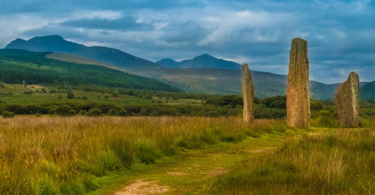
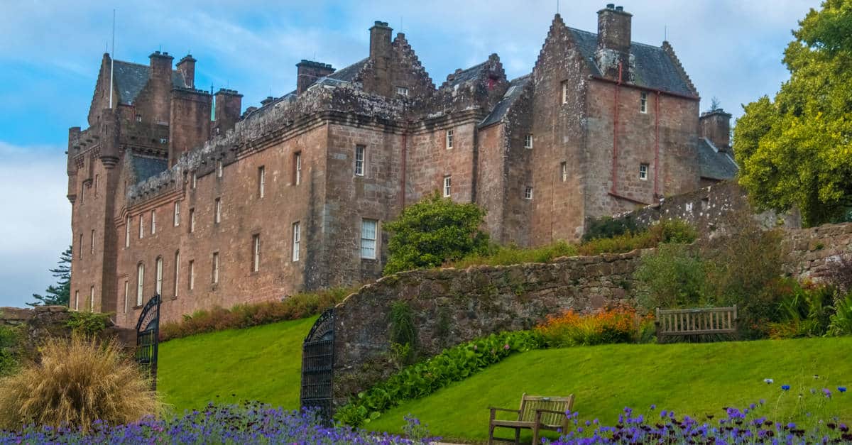
But, to make the most of the scenery and landmarks along the route, such as the celebrated Brodick Castle, King’s Cave, Lochranza Castle, Machrie Standing Stones, and the Iron Age hill forts and burial cairns, my personal recommendation is to plan a 7 to an 8-day walking holiday.
I opted for a 7-day itinerary and stayed at wild or designated campsites. My adventure looked something like this:
My 7-Day Itinerary
- 1st Stage: Brodick to Sannox (low-level route)— 7.7 miles
- 2nd Stage: Sannox to Lochranza—9.75 miles
- 3rd Stage: Lochranza to Imachar—9 miles
- 4th Stage: Imachar to Blackwaterfoot—10 miles
- 5th Stage: Blackwaterfoot to Lagg—6.5 miles
- 6th Stage: Lagg to Whiting Bay (via the Headlands)—9.5 miles
- 7th Stage: Whiting Bay to Brodick (Glenashdale Falls route)—11 miles
If you want to avoid boulder scrambling, rugged terrain and tidal challenges, there is an alternative route between Lagg and Whiting Bay. It is a bit longer, but easier. To avoid either or both of the two headlands, you can switch between the two routes.
Glenashdale Falls were well worth the detour. But, if you’d rather not visit the waterfall, you can take the coastal route. It is just as long as the Waterfall route.
This said, the route is officially divided into 8 sections. If you plan a 8-day itinerary, your last two days of walking could look something like this:
- 7th Stage: Whiting Bay to Lamlash—6 miles
- 8th Stage: Lamlash to Brodick—5 miles
If you are planning a shorter but more challenging walking holiday, the following 6-day itinerary may work better for you:
6-Day Itinerary
- 1st Stage: Brodick to Sannox—7.7 miles
- 2nd Stage: Sannox to Lochranza—9.75 miles
- 3rd Stage: Lochranza to Machrie— 13 miles
- 4th Stage: Machrie to Lagg/Kilmory—13 miles
- 5th Stage: Lagg/Kilmory to Whiting Bay—9 miles
- 6th Stage: Whiting Bay to Brodick—12 miles
Highlights
There is plenty to do and see on Arran Island. Many of the landmarks of the Island are located on the route, while some require just a short detour. Some of the highlights of the route include:
- Brodick Castle
- Goat Fell
- King’s Cave
- Lochranza Castle
- Stunning coastline
- Black Cave
- Lochranza Distillery
- Machrie Moor Stone Circles
Dog Walking on the Arran Coastal Way
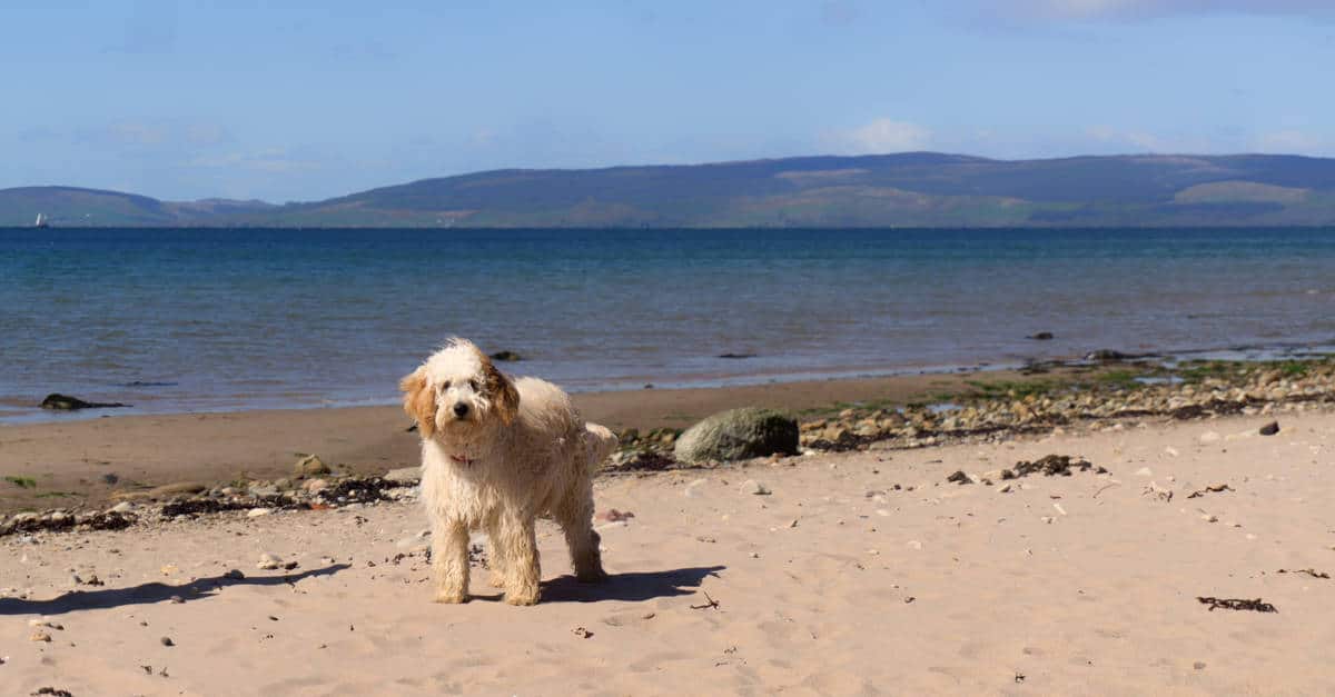
The Isle of Arran has branded itself as a dog-friendly place. However, I am not sure that they are quite there yet, but they are definitely getting there.
Dogs can cause cows, horses, and wild animals to take fright, and there are many of them on the trail.
You will need to keep your dog on a short lead when you approach fields with animals and follow the Outdoor Access Code for responsible dog walking.
Please note that many accommodation providers don’t allow pets. But, as long as you book your accommodation well in advance, you will be fine.
Check out our post on walking the West Highland Way and St Cuthbert’s pilgrimage.
I love hiking, backpacking, and camping. From the Camino de Santiago to the West Highland Way in Scotland or simply a great day hike on the weekend. Hiking refreshes me, my mind, and keeps my body reasonably fit. So far I have walked three Camino routes and many other long distance hikes in the UK, Canada, and around the rest of Europe. One of the best was my hike up Ben Nevis.