The Pennine Way is a famous and challenging long-distance hike in England. One of the 16 National Trails, a chain of walks throughout England and Wales, it’s the oldest of the bunch, after being officially founded in 1965.
It’s an impressive 431 kilometres in length (or thereabouts, according to how it’s measured), and runs from Kirk Yetholm, a small village just inside of the Scottish border, to Edale, another small village in Derbyshire, relatively close to Manchester.
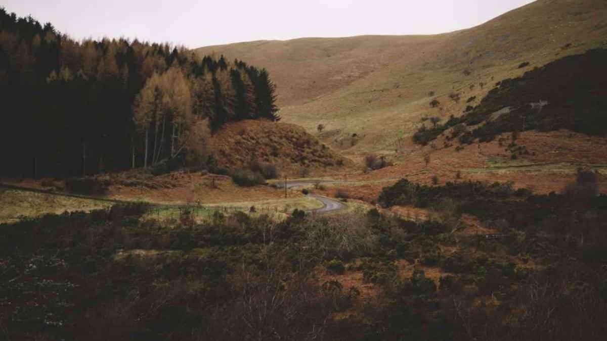
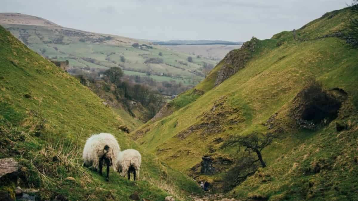
The Pennine Way is a real challenge – it’s famously (and infamously!) known as the toughest of all the National Trails. The walk is beautiful, offering sights and scenes of hills, waterfalls, wildlife and more. It’s also a fantastic way to become immersed in the culture of England’s rurality. The trail can be walked either north to south or south to north.
Which Way Should I Walk – North To South or South To North?
Generally speaking, the vast majority of walkers take the trip from south to north. Hiked in this direction, you walk with your back to the worst of the weather. This is an essential consideration – even if you undertake this trek in the summer, you’re probably going to endure days with some poor weather. Such is life in England! British weather is notoriously unpredictable.
So you should prepare for some rain and some wind, and therefore prepare to walk south to north. That said, if you live close to Kirk Yetholm, the appeal of walking in the direction of home might be enough of a temptation to convince you to walk in the unconventional direction of south to north. But it’s rare that walkers venture in this direction.
Where Will The Trail Take Me?
Many hikers and guidebooks consider this trek to be the ultimate National Trail, largely because of its diversity and its length. It crosses three separate National Parks along with one officially designated Area of Outstanding National Beauty. Assuming you walk from south to north, you’ll pass through these regions in this order:
- Peak District National Park: Edale, the starting point of the walk, lies in this National Park, so the first stretch of your trek begins in exciting National Park territory. This part includes Kinder Scout plateau and Jacob’s Ladder.
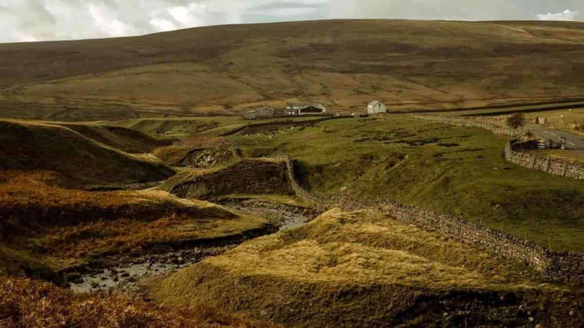
- Yorkshire Dales National Park: You’ll cross through lakes, rivers, and traditional Yorkshire villages. You’ll also hit Pen Y Ghent, one of the famous three peaks.
- North Pennines Area of Outstanding Natural Beauty: The stretch after which the walk is named, this part borders the Yorkshire Dales National Park, taking you seamlessly from one set of rolling hills to another. Peatlands, moors and more, this stretch is beautiful – and it offers the highest point of the entire trek.
- Northumberland National Park: This stretch carries you across dramatic views, heathery moors and 8km of the Hadrian’s Wall Path. You’ll reach almost the very end of the walk as the National Park reaches its end at the border between England and Scotland.
The vast majority of the walk is located in these four places, so almost every step of the way takes you through views, vistas and stunning nature.
Why Should I Walk The Pennine Way?
There are many reasons!
- First of all, it really is beautiful. This is one of the world’s best walks. You’ll meet fantastic views, fantastic people and fantastic culture. The walk is a brilliant way to encounter the views, history, and people of this part of the UK.
- For the challenge. Any long-distance walk is a big task. And this one is no different. The sense of accomplishment at the end of any hike is fantastic. And the longer the hike, the bigger the sense of accomplishment.
- It’s a great way to get healthy and active. Hiking is great for your body and mind!
- To join the community of the millions of people who’ve hiked at least some of this path.
- For the many famous sites and scenes across the way…
What Are Some Of These Sites?
The Pennine Way has a huge amount of famous and varied landmarks, sights and views along the way. Some of these include:
- Kinder Scout: a moorland plateau close to Manchester, this is the highest point in The Peak District National Park at 636 meters. The unique landscape is almost otherworldly in appearance, and the spot offers great views of the surrounding area. The paved ascent of Jacob’s Ladder is a particular highlight of this section of the walk.
- Black Hill: another part of the Peak District, this peaty morass features paved stones taking hikers over boggy land. The paved path allows hikers to cross the feature without getting wet and soggy… which wasn’t always the case!
- Stoodley Pike: a huge monument built in the middle of nowhere, originally to commemorate the defeat of Napoleon. It stands tall and proud, set isolated in the middle of moors and marshes. It’s close to the beautiful town of Hebden Bridge, where many walkers choose to spend some time.
- Malham Cove: formed by a waterfall in the most recent ice age, this huge cove now has a limestone path running across its top. This limestone path resembles stepping stones, just without a river underfoot. The approach to Malham Cove, and the views from its top, are both beautiful parts of the Pennine Way.
- Pen Y Ghent: part of The Yorkshire Dales National Park, this peak has an altitude of 694 meters. Translated as ‘Hill of the Winds,’ it’s a blustery summit (and a steep one). Both the views of Pen Y Ghent and the views from Pen Y Ghent are beautiful.
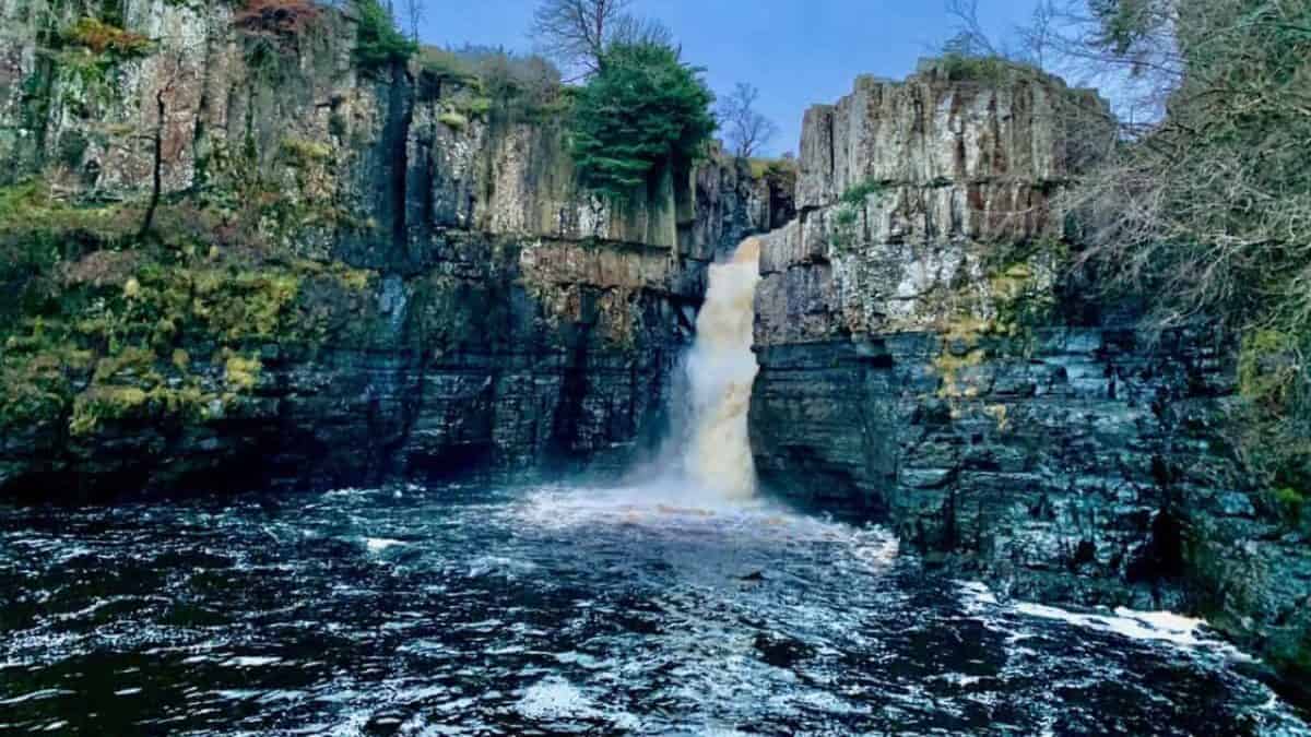
- High Force Waterfalls: located in the North Pennines Area of Outstanding Natural Beauty, it’s one of the biggest and most beautiful waterfalls in England.
- High Cup Nick: located less than 20km from High Force Waterfalls, this u-shaped valley is gorgeous and dramatic. Originally formed by glaciers, the views from here stretch on forever.
- Cross Fell: another spot in the North Pennines Area of Outstanding Natural Beauty, it’s the highest point of the entire Pennine Way, at 893 meters. If you can reach here in good weather, the views are incredible. This part of the walk is infamous for wind, which creates shrill sounds as it blasts across the surface of the peak.
- Hadrian’s Wall: a small section of the trail takes you alongside Hadrian’s Wall, one of the most significant Roman sites in the whole of the UK. The wall was built was Emperor Hadrian to prevent invasion. The part of the wall which runs alongside The Pennine Way is perhaps the most preserved section.
- The final crossing into Scotland: the last stretch of the route meanders back and forth between England and Scotland. The last time you leave England, you do so for the village for Kirk Yetholm, just inside the Scottish border. Upon crossing this border for the last time, you know your walk is very nearly (and bittersweetly) over.
What If I Only Want To Walk Some Of The Pennine Way? Are There Any Notable Stretches?
This is a question many people ask. And the vast majority of people who set foot upon The Pennine Way only walk some of it. Every single day, walkers simply hike day-long stretches of the walk, while others cover larger portions over two or three days.
If you don’t want to commit to the entire 431-kilometre challenge, you have many options. You might want to pick one or two of the highlights covered above and tackle a section that includes them. Alternatively, you can choose one of the most famous stretches. Here are some of our favourite one-day sections:
- Byrness to Kirk Yetholm – 45km: this part is rocky and remote, and takes you through the wilderness of Northumberland, one of England’s most beautiful counties. It’s also the traditional final stretch of the walk, so you’ll get (almost) the same sense of accomplishment of those who have walked the entire way without having to do so yourself!
- Middleton-in-Teesdale to Dufton – 32km: you’ll pass three waterfalls – Low Force, High Force and Cauldron Snout, along with High Cup Nick. And not only is this section full of highlights, it also carries you through beautiful meadows.
- Greenhead to Bellingham – 33km: more wonderful Northumbrian views, gentle ups and downs and the stretch which includes Hadrian’s Wall
- Edale to Crowden – 26km: this is the beginning of the route, and is a great way to get a taste of what tackling the full walk can bring. And you get to encounter the Kinder Plateau! If you’re considering doing a small trail run to see what long-distance walking is like, this is a great way to start testing whether or not you’re ready for the full Pennine Way.
What If I Do All Of The Walk? How Long Will It Take? Am I Fit Enough?
Most people who undertake the full hike do it in around 16-21 days. But how long it takes is up to you. Many people do the walk in 30 days! The world record is under three days. If you want a real physical challenge, choose a shorter time frame.
If your goal is geared more towards relaxation and recuperation, then you might choose to do the walk more slowly. There is no one true way to take on the walk. A big factor is your fitness level. Yes, you might be accustomed to one-day hikes.
But walks of this length are a different beast. You should undertake some preparatory walks to make sure your body is capable and prepared. The Pennine Way is the toughest of the National Trails, so treat it with the respect that it deserves.
Often, a long-distance walk can surprisingly (and annoyingly) reveal niggles, injuries and joint weaknesses that you didn’t even know were there. So do some preparation first! Do a couple of weekend walks, with overnight stays. If they’re easy, take a week-long walk. If that’s doable, and your body feels comfortable, you should be able to tackle The Pennine Way with confidence and certainty.
When Is The Best Time To Walk The Pennine Way?
It depends on the views, conditions, and temperatures you prefer: Summer will bring with it the best weather, the least mud, and the most fellow walkers. Summer also offers more daylight hours. All of the facilities on The Pennine Way will be open during summer.
Autumn has more cool climes, which can be refreshing if you don’t like to sweat constantly. But that can bring with it the volatility of British weather. If you hike in autumn you’re likely to encounter some days with wind and rain.
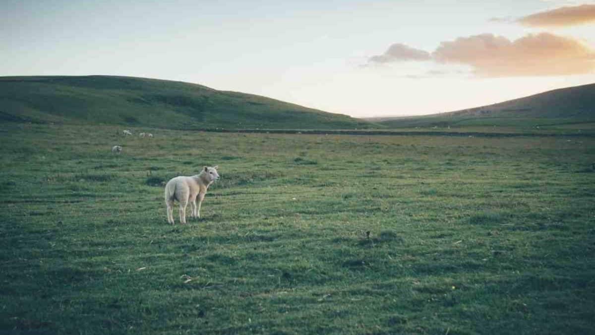
Autumn is a beautiful season in the UK, perhaps the most aesthetic of all. Spring is probably the best time if you want reliable weather which isn’t too hot. You might also be lucky enough to see lots of lambs in the farmlands you’ll cross, which can be a beautiful sight. Spring shouldn’t offer too much rain… but, again, British weather is famously unpredictable! Winter, unless you really want an adventurous trek, is a bad idea.
In winter, you’ll encounter bad weather and the real possibility of heavy, lying snow. The weather will make navigation tough, and lots of facilities will be closed. Unless you’re determined to undertake a feat of ultra-challenging survivalism, The Pennine Way during winter isn’t a good idea. I have a more in-depth post on the best time to hike the Pennine Way.
Is The Pennine Way Well-Marked?
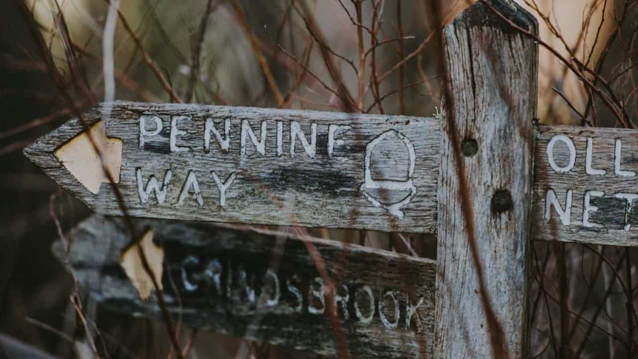
Generally speaking, the route is very well marked and signposted. Signs have ‘Pennine Way’ written on them or offer acorn symbols. When not specifically marked by actual signs, the paths are well-worn, making them easy to follow by instinct. And helpful locals and fellow walkers are often on-hand with advice en-route.
That said, the walk is by no means foolproof. Occasionally, tracks disappear, and from time to time there are no signs present. And the weather – no matter when you walk – will at some point make things hard to see. So it’s essential that you have a good map and compass – and that you know how to use them. This hike is by no means the most remote in the world, but it certainly should be approached with the same caution as any other long-distance trek.
How Difficult Is The Pennine Way?
The major difficulty here comes from the length of the walk rather than the challenge offered by any specific stretch. It’s not a hugely technical trek and doesn’t require heavy scrambling or scree. But there are a few sections that are harder than others.
A handful of ascents are steep and rocky, but none of the walk offers challenges unfamiliar to regular walkers. It’s also worth noting that the ascents and descents aren’t too strenuous for the most part. There are of course difficult stretches, but this certainly doesn’t compare to heavy mountaineering.
If you are looking for an even easier walk, check out our post on the best alternatives to the Pennine Way.
What About Elevation?
You’ll encounter a total elevation of a little less than 1200m which – when you consider the length of the walk – is really very little. To compare, one ascent of Everest measures in at 8,848 meters. Cross Fell is the highest point at 893 meters. It’s important to remember that while the total elevation isn’t huge, the constant movement of slight ups and downs can still be mentally and physically challenging.
What Gear Do I Need For The Pennine Way?
If you’re tackling the whole walk, you’re going to need a lot of equipment. I have another fuller post on what to pack for the Pennine Way.
- Clothes. Of course! You want to pack light, but you also want to ensure that you have enough clothing. For the sake of packing light, use as many Merino Wool clothes (which require way less washing) as you can, including hiking underwear and socks for hiking, Smartwool vs Icebreaker. And wear waterproofs. Minimize how much you need to carry and how much you need to wash. And don’t forget a hat!
- Good hiking shoes. These are essential. Make sure you have experience using the very shoes that you take with you. Unused shoes (or shoes you don’t have much experience with) can easily lead to blisters and injuries. This is a very important consideration. Read also best women’s hiking shoes.
- Water bottles and purification tablets. You absolutely need a couple of good-quality refillable water bottles to keep you hydrated along the way. And though you might not necessarily need them, water purification tablets are great if you can’t find fresh, running water. This is fairly unlikely but it’s always good to avert disaster before it strikes.
- Map and compass. Have a very good map (or more than one if needed). And make sure your compass is good too. It’s essential that you can read a map and compass for this trip.
- First aid kit. You’re likely to need some sort of medical care en-route, even if it’s a simple bandage, bandaid or painkiller. This kit should be of good quality and include rehydration sachets along with sunscreen.
- Trekking poles. Give your joints some respite. See carbon fibre poles vs aluminium trekking poles
- Food. Depending on whether or not you’re camping, the amount of food you need will vary greatly. But whatever type of accommodation you’re using, you’ll absolutely need snacks. Take lightweight, calorie-dense treats and nibbles to lighten the load on your back.
- Camping equipment (optional). Some people camp along this trek, while other people stay in accommodation. Camping brings with it more freedom and more isolation, but it also means more to carry, especially if you’re cooking your own meals etc. But if you are camping, you should ensure all of your gear is lightweight, high-quality and reliable. If you want to cook en-route, you’ll need cooking gear, like a backpacking stove.
Where Should I Sleep On The Pennine Way? What Are My Accommodation Options?
Most hikers don’t camp and instead rely on accommodation en route. There are plenty of accommodation options throughout the entire trek, and these can be a great way to get closer to heritage, history, culture and people. And they also offer well-needed comfort after kilometres of walking!
There are a huge amount of options along the way, running all the way from hotels to hostels. You can also stay in caravans, camping barns, stone huts, guesthouses, family homes, bed and breakfasts and more. The accommodation options are as varied as the walk itself. It would be impossible to list all the options, but here are some of the highlights that can offer you a night of peaceful slumber along the way:
- Upper Booth Camping Barn, Edale (http://www.upperboothcamping.co.uk/): this is a great no-frills rustic stone barn set in a working farm. There’s no electricity, no inside running water, and no heating, but there are plenty of warm welcomes. This is a great introduction to working farm life, the kind you’ll see throughout the entire trek.
- The Youth Hostel Association (or YHA) has plenty of lovely hostels along the way, all offering an affordable and sociable way of getting a comfortable sleep and meeting fellow hikers. The YHA at Mankinholes is one of the best.
- Bothies! (https://www.mountainbothies.org.uk/) If you’ve never used a bothy, now’s the time to do it. Bothies are rudimentary stone shelters and can be used by anyone – for free! But they offer very little aside from shelter, so they’re only a good option if you have a sleeping bag – or if you don’t mind sleeping in your own clothes. There are four bothies along the trail. For a really rustic, remote sleep, these are great.
- The Green Dragon (https://www.thegreendragoninnhardraw.com/), Hardraw. A proper pub, with wooden panels and an open fire. If you want a taste of real British pub life, this is a great place to get it while you rest overnight.
- The Farmers Arms (http://www.farmersarmsmuker.co.uk/), Muker. Another traditional pub, this time with the historical black and white facade that so many pubs have now lost. It’s hiker-friendly, dog-friendly and just friendly!
- Tan Hill Inn, Reeth (https://www.tanhillinn.com/). This inn has a legendary reputation as the highest pub in England and sits at an altitude of 528 meters. It’s a beautiful but basic affair, remote and rural but very traditional. In spite of its great reputation, it still offers very affordable accommodation for both campers and non-campers.
- Demesne Farm, Bellingham (http://www.demesnefarmcampsite.co.uk/). Another great working farm, this is typical Northumbrian in its landscape and its hospitality. Again, it offers accommodation for campers and non-campers.
- The Border Hotel, Kirk Yetholm (https://www.borderhotel.co.uk/walking-penine-way/). The endpoint of the walk, this place certainly offers a welcome place to sit, eat and drink. And for those looking to really indulge in finishing the walk, they offer accommodation! The Border Hotel gives certificates to walkers who’ve just finished the trek, along with a free half-pint of beer. But if you’ve just finished hundreds of kilometres of walking, you’ll probably want more than half a pint.
Related Hikes:
Related:
Are There Places To Eat And Drink Along The Way?
There are plenty, from cafes and restaurants to pubs and chip shops. There are also many small shops, where you can stock up on snacks and picnic supplies. But you should always overestimate how far apart these are. You don’t want to be left without food, so always make sure you have plenty of rations to take you from pit stop to pit stop.
A note on food and drinks on the Pennine Way, the has some great places to eat and experience the traditional pub culture of the north of England. If you’re not from the north of England (or even if you are!), you’ll find lots of traditions that you’ll fall in love with. Traditional British pubs are a thing that truly can’t be replicated elsewhere. So use this trip as a way to indulge in learning about that culture through many meals and a few beers. British pub food is great. And traditional British beer is great.
British pub culture also offers an insight into British life in a way that no other thing can. So make sure you eat and drink plenty – and make sure you talk to the locals, who are always full of conversation and hospitality! Overall, The Pennine Way offers so much awe and opportunity.
Nowhere else can you combine views, culture and the great outdoors in the same way. This part of the world is beautiful, welcoming and inspiring – and The Pennine Way is the best way to explore and experience it. Lace up your boots, pack your bag and enjoy!
I love hiking, backpacking, and camping. From the Camino de Santiago to the West Highland Way in Scotland or simply a great day hike on the weekend. Hiking refreshes me, my mind, and keeps my body reasonably fit. So far I have walked three Camino routes and many other long distance hikes in the UK, Canada, and around the rest of Europe. One of the best was my hike up Ben Nevis.